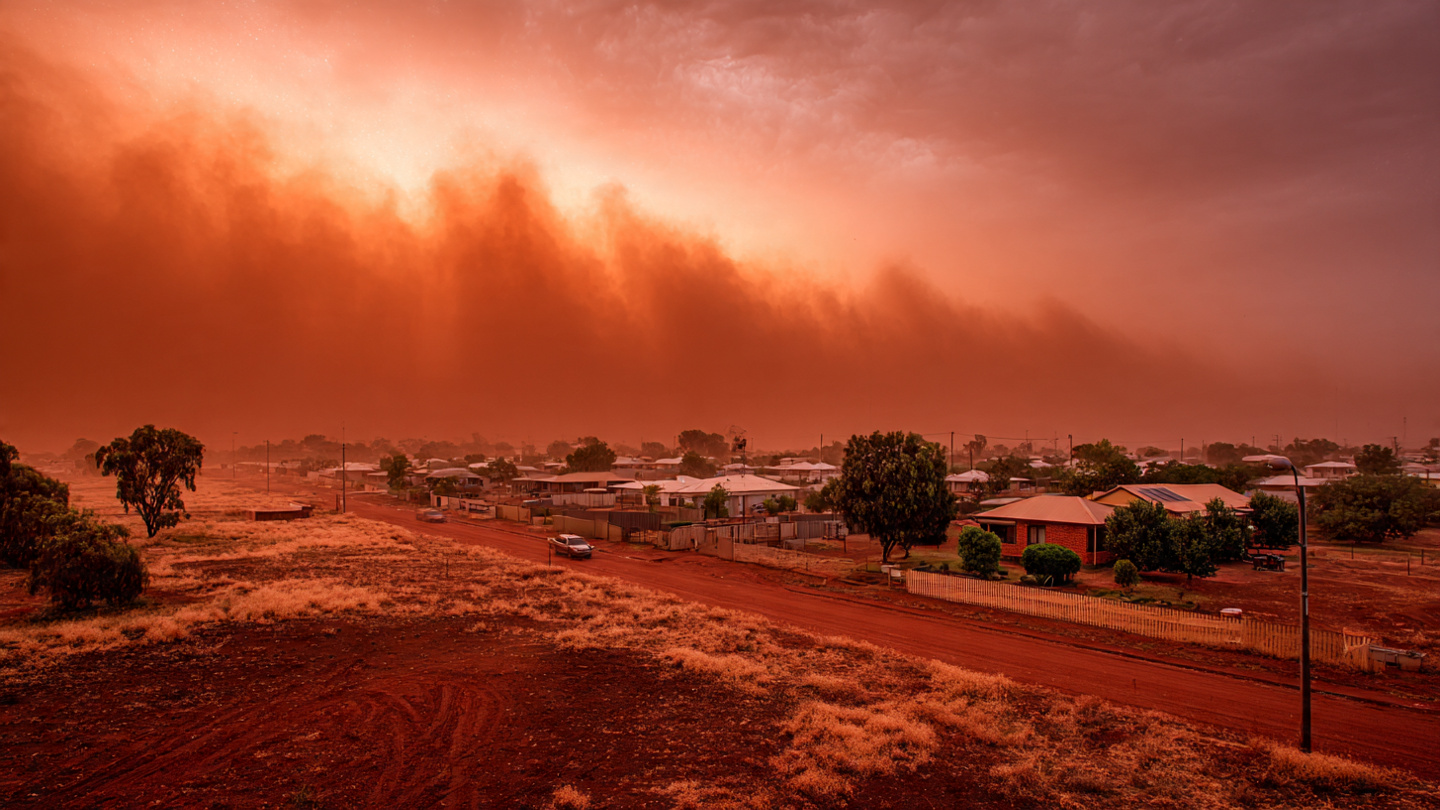
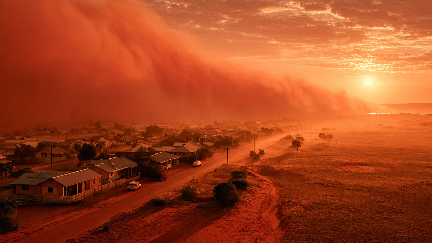
There are few natural events more unsettling than looking up and seeing the sky glow in deep red, as if the landscape has slipped into another world. In Western Australia, that eerie vision became reality when powerful winds linked to Tropical Cyclone Narelle swept across iron-rich terrain and hurled vast amounts of dust into the atmosphere. The result was a dramatic blood red sky that stopped people in their tracks, sparked global curiosity, and reminded us just how quickly nature can alter the mood of an entire region.
What made this event so captivating was not just its beauty, but its strangeness. Streets, coastlines, and open country appeared drenched in a rusty haze. Sunlight filtered through airborne particles in a way that made the whole sky look almost Martian. For anyone who has ever experienced a dust storm at sunset, the feeling is unforgettable: the air turns heavy, familiar landmarks look surreal, and the ordinary suddenly feels cinematic.
This extraordinary weather event was not a mystery of the supernatural. It was a striking example of atmospheric science in action. Western Australia red sky conditions emerged because strong cyclone-driven winds lifted fine particles from inland areas rich in iron oxide, sending them high enough to spread across the region and alter the way light moved through the air. Understanding how that happened reveals a bigger story about dust transport, severe weather, climate patterns, and the emotional power of the natural world.
What Caused the Blood Red Sky in Australia?
The red sky event over Western Australia was driven by a combination of meteorology, geology, and light physics. At the center of it all was Tropical Cyclone Narelle, a powerful system whose wind field helped stir loose surface material from dry inland landscapes. Even areas far from the cyclone’s core can experience strong gusts, turbulent air, and widespread dust uplift.
Western Australia contains vast stretches of land marked by iron-rich soil. When fine reddish dust from these regions becomes airborne, it can dramatically tint the sky. That color comes from iron oxide, the same compound that gives rust its familiar red tone. Once suspended in the atmosphere, the particles interact with incoming sunlight, scattering shorter wavelengths and allowing warmer red and orange hues to dominate what people see from the ground.
In simple terms, the sky did not change color on its own. It was filtered through a thick veil of mineral dust.
- Primary driver: strong winds associated with Tropical Cyclone Narelle
- Dust source: dry inland surfaces and iron-rich soil in Western Australia
- Color mechanism: dust particles scattered blue light and emphasized red wavelengths
- Visual effect: a dense, rust-colored haze that created an apocalyptic red sky appearance
This kind of event is rare enough to feel shocking, but common enough in principle to be scientifically understood. When weather systems, dry land, and fine mineral dust align, remarkable sky colors can emerge.
Why the Sky Looked So Red
The Science of Light and Dust
To understand the Australia blood red sky phenomenon, it helps to look at how sunlight behaves. White sunlight contains all visible colors, but those colors do not move through the atmosphere equally. Shorter wavelengths, such as blue and violet, scatter more easily when they collide with small particles and molecules. This is why the sky usually looks blue on a clear day.
During a major dust event, the atmosphere becomes crowded with larger particles. Those particles change the balance of scattering and absorption. Instead of light passing through relatively clean air, it travels through a thick layer of reddish-brown mineral dust. The dust absorbs and diffuses portions of the light spectrum while allowing more red and orange tones to dominate the visual field. The denser the airborne dust, the more intense the effect can become.
At sunrise and sunset, the effect often intensifies because sunlight must travel through more of the atmosphere at a lower angle. But in severe dust storms, the red cast can linger through broader parts of the day, making the entire scene feel unnatural and deeply dramatic.
I have always found events like this fascinating because they show how the atmosphere is not just invisible space above us. It is a living filter, constantly reshaping color, contrast, and depth. A landscape can go from bright and familiar to dim, coppery, and almost alien in less than an hour.
Why Western Australia Is Especially Vulnerable
Western Australia weather can be extreme, especially across dry and semi-arid regions where exposed soil is easily disturbed by strong winds. The state’s massive land area, sparse vegetation in some zones, and naturally red earth make it especially susceptible to spectacular dust events under the right conditions.
When strong systems develop offshore or move along seasonal pathways, they can influence inland airflows enough to lift and spread dust over great distances. This does not always create a blood red sky, but it does raise the odds of unusual atmospheric coloring when the dust contains enough iron-rich material.
That is part of what made this event so visually powerful: the local geology was already primed to contribute vivid color once the winds arrived.
The Role of Tropical Cyclone Narelle
Tropical Cyclone Narelle was the catalyst that turned a dusty landscape into a spectacle visible across the sky. Cyclones are often associated with rain, storm surge, and destructive coastal weather, but one of their less discussed impacts is how their wind patterns can influence dry continental interiors. Even if a cyclone is not making direct landfall over a specific community, its broader circulation can generate strong gusts and unstable atmospheric conditions over a wide area.
In this case, those winds helped loft fine sediment into the lower and middle atmosphere. Once airborne, the dust could travel and spread, blanketing parts of Western Australia in a rusty haze. Depending on the concentration of particles, visibility may drop, air quality can worsen, and the sky can take on unusual tones ranging from orange and copper to dark red.
This is an important reminder that a cyclone’s influence extends beyond heavy rain bands. Weather systems operate as connected structures. The dramatic sky seen by residents was not an isolated incident but part of a larger chain of atmospheric events linked to regional circulation and land-surface conditions.
- Cyclone winds can lift dust far from the storm center
- Dry soil conditions increase the amount of loose sediment available
- Fine particles stay suspended long enough to change sky color over broad areas
- Air quality impacts may accompany the visual spectacle
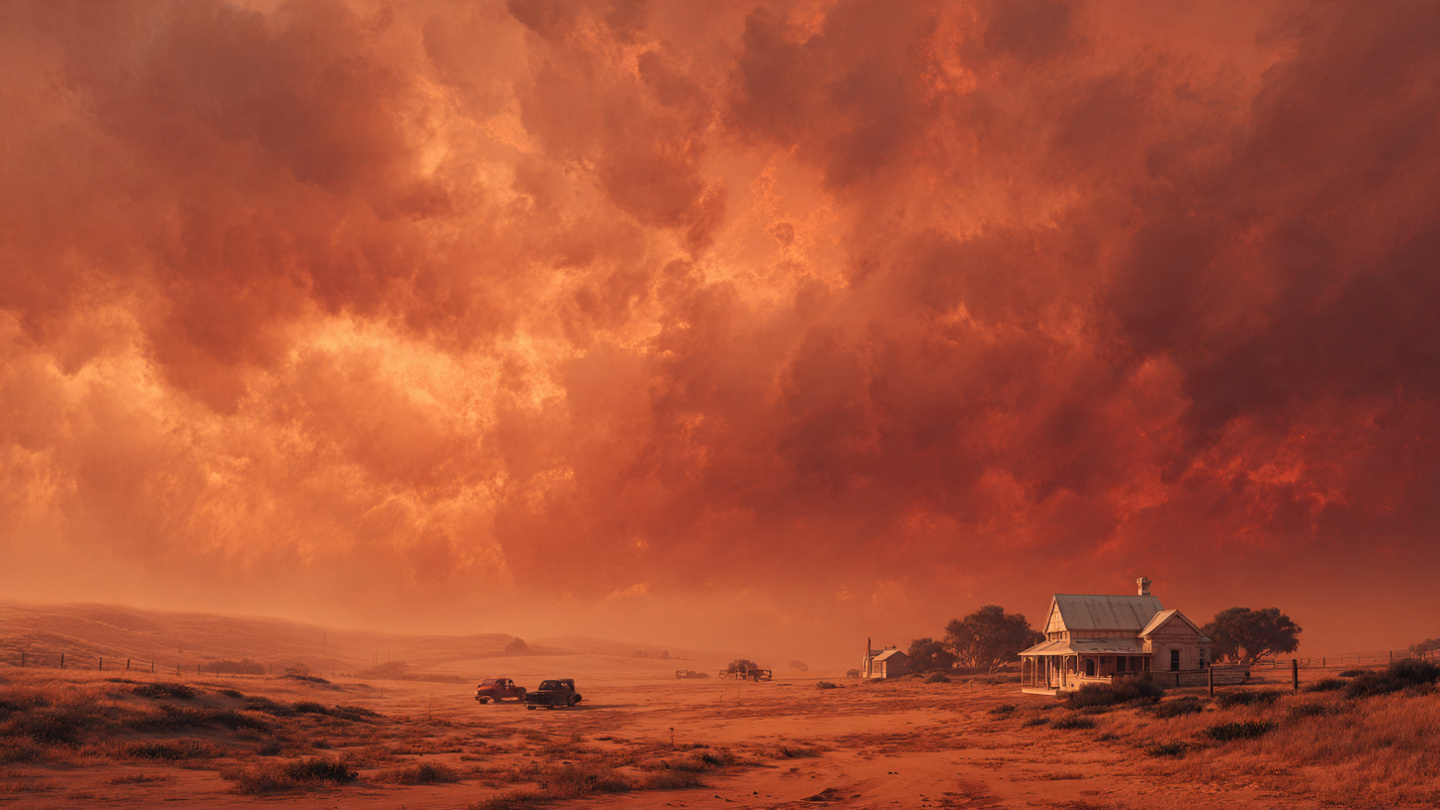
Why the Scene Felt Apocalyptic
Descriptions like “apocalyptic” are often overused, but in this case, they make emotional sense. A red sky taps into something primal. Humans are highly responsive to unexpected changes in environmental color because color often signals danger, fire, storm activity, or major atmospheric disruption. When daylight suddenly turns red, it can create a visceral sense that something is wrong, even when the cause is entirely natural.
That psychological effect is amplified when familiar surroundings lose their normal appearance. Roads look dimmer. Buildings seem coated in sepia. Shadows disappear into haze. The horizon blurs. What should feel ordinary suddenly feels like a scene from a disaster film.
There is also cultural weight behind the image of a red sky. Across literature, religion, folklore, and modern media, red skies are associated with warning, upheaval, or transition. So when a real-world red sky in Western Australia appears, people do not just observe it. They interpret it emotionally.
Yet that emotional response does not diminish the science. If anything, it deepens public interest in it. The more dramatic the sky becomes, the more people want to understand what forces produced it.
Dust Storms, Red Skies, and Climate Questions
Whenever a striking weather event captures attention, an important question follows: is this connected to climate change? The honest answer is that no single event should be oversimplified. A dust storm in Australia can occur naturally when dry ground, wind, and atmospheric instability combine. However, broader climate trends can influence how often landscapes become vulnerable to dust uplift in the first place.
Longer dry spells, heat extremes, land degradation, and changing rainfall patterns may leave more soil exposed and fragile. That does not mean every red sky is a direct climate signal, but it does mean the background conditions that make dramatic dust events possible can be shaped by a warming world.
Scientists typically look at long-term patterns rather than one-off spectacles. They ask whether drought is becoming more frequent, whether vegetation cover is changing, whether soil moisture is declining, and whether severe weather systems are interacting differently with land surfaces. Those are the deeper questions hidden behind a headline-grabbing red sky.
For readers trying to make sense of these events, the best approach is to hold two truths at once: this was a natural atmospheric event, and it may also fit into a broader story about increasingly stressed landscapes.
How Dust in the Air Affects Daily Life
While the visuals attract most of the attention, airborne dust can also create practical concerns. A red sky may look mesmerizing in photos, but heavy dust in the atmosphere can reduce visibility, irritate the eyes, and worsen respiratory symptoms for vulnerable groups. People with asthma, chronic lung disease, or allergies may feel the effects quickly.
Drivers may also face changing road conditions when visibility drops. Outdoor workers, farmers, and coastal residents can experience disruption if dust settles across equipment, buildings, or transport routes. In severe events, even simple routines like exercising outside or hanging laundry become less appealing.
That is why dramatic weather should be appreciated with caution as well as curiosity. Beauty and hazard often arrive together in the natural world.
Practical Ways to Stay Safe During a Major Dust Event
- Check local weather alerts and air quality updates before traveling
- Stay indoors when dust concentrations are high, especially if you have respiratory conditions
- Keep windows and doors closed to reduce indoor dust exposure
- Use masks or filtration where appropriate if outdoor activity is unavoidable
- Drive carefully and use headlights if visibility becomes poor
These steps may sound simple, but they matter. Spectacular sky events are easiest to enjoy when basic safety is taken seriously.
Why Images of the Red Sky Spread So Quickly
One reason this event captured attention far beyond Australia is that it was inherently visual. In an age of instant photography and social sharing, unusual atmospheric events travel fast. A single striking image of a crimson sky over a quiet suburb or empty coastline can spark thousands of reactions within minutes.
But this event also resonated because it balanced beauty and unease. People are drawn to scenes that feel both gorgeous and slightly disturbing. The apocalyptic blood red sky checked every box: rare color, real science, emotional intensity, and a strong sense of place.
From an engagement perspective, events like this remind us how powerful weather storytelling can be. Audiences do not just want raw facts. They want to know what caused the phenomenon, what it felt like on the ground, whether it was dangerous, and what it might mean in the future. A sky that turns red becomes a gateway into geology, meteorology, climate science, and human perception all at once.
What This Event Reveals About Australia’s Landscape
Australia’s environments are uniquely suited to producing visually dramatic weather. The continent’s broad dry zones, mineral-rich soils, intense heat, and volatile weather systems create conditions that can be both harsh and breathtaking. The red sky over Western Australia was not just a storm story. It was also a landscape story.
The same iron-rich earth that gives inland regions their iconic color also provides the raw material for these airborne spectacles. When wind and dryness align, the land itself appears to rise and repaint the sky. There is something deeply Australian about that image: earth and atmosphere blending into one unforgettable scene.
It is also a reminder that nature rarely operates in neat categories. A cyclone offshore can shape a dust event inland. Soil chemistry can affect the color of the sky. A local weather event can become an international conversation. The atmosphere is not separate from the land beneath it. They are part of one connected system.
Conclusion: A Red Sky That Told a Bigger Story
The blood red sky in Australia was more than a startling visual moment. It was the product of powerful winds, iron-rich dust, and the complex physics of light interacting with the atmosphere. Tropical Cyclone Narelle provided the force, Western Australia’s red earth supplied the material, and sunlight did the rest. What emerged was a scene that looked almost unreal but was firmly grounded in science.
Events like this matter because they capture attention in a way few scientific explanations can on their own. They make people stop, ask questions, and look more closely at the world around them. And that curiosity is valuable. It leads us from a shocking image to a richer understanding of weather systems, land conditions, air quality, and the fragile balance between environment and climate.
If you are fascinated by rare atmospheric events, now is the perfect time to follow regional weather patterns more closely, learn how dust and light shape what we see, and pay attention to how changing environmental conditions may influence the skies of the future. The next extraordinary sky may arrive with little warning, but understanding it begins long before you look up.
For more deep coverage of extreme weather, unusual sky phenomena, and the science behind the world’s most unforgettable natural events, stay connected and keep exploring. The atmosphere always has another story to tell.


